
The EUDI Wallet Dilemma: Are We Handing Digital Identity to Big Tech?
The Architecture of the EU Digital Identity Wallet The European Digital Identity (EUDI) Wallet represents one of the most ambitious digital…
In the immediate aftermath of a seismic event, every second functions as a critical variable in the equation of survival. Historically, disaster management relied heavily on ground-level surveys, where emergency responders were forced to navigate physically unstable terrain to gauge the extent of the damage. This traditional approach, while thorough, is inherently slow and fraught with extreme danger, often delaying the arrival of life-saving equipment. Today, however, the paradigm has shifted toward orbital monitoring, which allows humanitarian agencies to gain a comprehensive, bird’s-eye view of a catastrophe within hours, if not minutes, of a tremor occurring.
High-resolution satellite imagery serves as the modern first line of defense, transforming how we perceive and react to ground-level devastation. By capturing granular details of structural integrity, debris accumulation, and blocked transit corridors, these orbital sensors provide an immediate roadmap for search and rescue operations. This technological leap means that instead of waiting for localized reports from isolated zones—which may be cut off by collapsed infrastructure—command centers can instantly identify which neighborhoods require the most urgent deployment of medical supplies and heavy machinery. The ability to visualize the scale of destruction from space effectively bypasses the limitations of geography, ensuring that relief efforts are directed with precision rather than guesswork.
The transition from manual on-site assessments to digital orbital analysis has drastically improved the logistics of international aid. In regions like those recently impacted in Venezuela, where terrain can be difficult to traverse and communication lines are often severed by seismic activity, satellite data acts as the central nervous system for relief coordination. By comparing pre-disaster images with current captures, analysts can highlight specific anomalies, such as pancaked apartment complexes or bridges that have been rendered impassable. This analytical transparency allows governments and NGOs to coordinate the movement of personnel and resources across vast, rugged landscapes, ultimately optimizing the flow of aid where it is needed most.
The integration of satellite technology into disaster response isn’t just about observation; it is about creating a data-driven framework that minimizes response times, maximizes safety for first responders, and ensures that limited resources reach the most vulnerable populations as quickly as possible.
Ultimately, the role of satellite technology in modern earthquake relief is defined by its capacity to provide clarity amidst the chaos. As these tools continue to evolve, incorporating machine learning to automatically detect structural damage, the efficiency of these humanitarian missions will only continue to grow. By turning raw orbital data into actionable intelligence, we are moving toward a future where the initial shock of a disaster is met with a synchronized, intelligent, and rapid response that saves lives that might otherwise be lost to the delays of traditional scouting.
Mapping the devastation caused by a major earthquake requires far more than simply snapping a high-resolution photograph from orbit. While traditional optical imagery—which functions similarly to a standard camera—provides vivid, recognizable pictures of the terrain, it is often rendered useless by environmental factors such as dense cloud cover, heavy smoke from fires, or the darkness of night. To overcome these limitations, disaster response teams rely on Synthetic Aperture Radar (SAR), a sophisticated technology that transmits microwave pulses toward the Earth’s surface. Because these wavelengths can penetrate atmosphere, clouds, and smoke with ease, SAR allows satellites to “see” through obstacles that would otherwise blind conventional sensors, ensuring that critical data reaches relief teams regardless of the weather conditions on the ground.
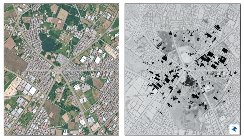
The true power of this remote sensing lies in the sophisticated application of change detection algorithms. By meticulously overlaying pre-quake satellite archives with real-time post-disaster data, computers can identify minute discrepancies between the two temporal snapshots. These algorithms look for specific geometric and electromagnetic markers that signify physical disruption, such as the sudden flattening of a building’s footprint, the accumulation of rubble in street corridors, or the jagged displacement of paved roadways. By automating this analytical process, researchers can pinpoint “damage hotspots” across vast, inaccessible regions in a fraction of the time it would take human analysts to review images manually.
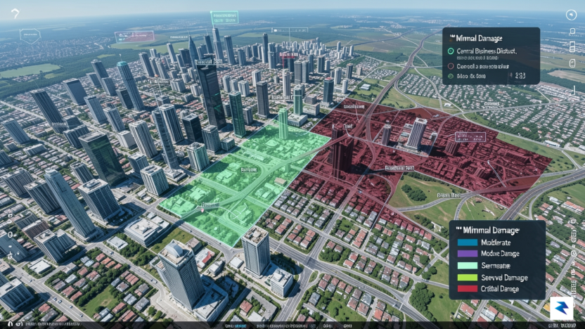
The integration of SAR and optical data creates a comprehensive “damage map,” providing emergency responders with a bird’s-eye view of where infrastructure is most compromised, even when physical access is blocked by terrain or debris.
Beyond identifying collapsed structures, these remote sensing techniques are vital for assessing the secondary impacts of tectonic activity. For instance, SAR interferometry can detect subtle shifts in ground elevation, which helps geologists and engineers determine if the underlying foundation of a bridge or dam has been compromised. This high-level analysis allows humanitarian organizations to prioritize the delivery of resources, ensuring that heavy machinery and medical teams are directed toward the areas with the highest concentration of structural failures. As this technology continues to evolve, the ability to rapidly synthesize complex spatial data into actionable intelligence is becoming the cornerstone of effective disaster management in earthquake-prone regions like Venezuela.
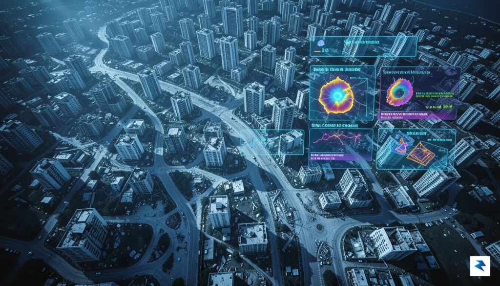
The sheer volume of raw satellite data captured in the immediate aftermath of a seismic event can be overwhelming, but raw pixels hold little value until they are synthesized into actionable intelligence. The process begins the moment a satellite passes over the affected region in Venezuela, transmitting high-resolution imagery back to ground stations. Once received, these images undergo a rigorous pre-processing phase where experts calibrate the data to account for cloud cover, lighting conditions, and sensor angles. By layering this current imagery against historical baseline maps of the region, researchers can instantly isolate structural anomalies, such as collapsed roofs, blocked arterial roads, or shifted terrain, allowing them to pinpoint precisely where the landscape has been fundamentally altered.
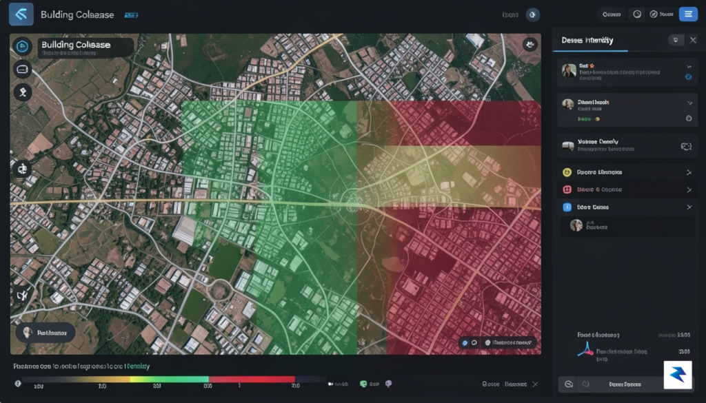
To accelerate this complex analysis, advanced artificial intelligence algorithms have become indispensable, acting as a force multiplier for human analysts. These machine learning models are trained to recognize the specific visual signatures of rubble and structural failure, scanning thousands of square miles in mere minutes. By automating the identification of debris, the software generates “damage density maps” that provide a bird’s-eye view of the crisis. These maps do not merely show where a building has fallen; they prioritize areas based on the severity of the destruction, helping search and rescue teams make critical decisions about where to deploy limited resources first. Consequently, the AI acts as a sophisticated filter, stripping away the noise of the disaster to highlight the locations where human life is most at risk.
The integration of automated debris detection reduces the time from image acquisition to field deployment from days to hours, fundamentally changing the survivability window for those trapped under rubble.
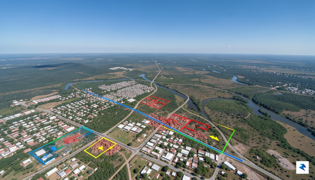
Once these maps are finalized, the information must be communicated rapidly to the boots on the ground. The final step of this data pipeline involves disseminating the processed intelligence to NGOs, government agencies, and international emergency response teams through secure, real-time cloud platforms. Field teams access these digital overlays via mobile devices, allowing them to navigate through debris-choked streets or locate remote villages that have been cut off from traditional communication channels. This seamless flow of information ensures that rescue efforts are not just reactive, but highly targeted and efficient. By bridging the gap between orbit and the earth, researchers are transforming abstract satellite data into a vital lifeline that guides rescuers directly to those who need help the most.

While high-resolution satellite imagery serves as a transformative tool for disaster response, it is far from a universal panacea. The technology relies on a complex interplay of physics and logistics, meaning that even the most advanced orbital sensors encounter significant hurdles that can obscure the reality on the ground. For rescue teams operating in Venezuela, these technical limitations create a “blind spot” that must be navigated with caution to avoid misallocating vital resources during the critical golden hours following a seismic event.

One of the most persistent obstacles is atmospheric interference, particularly the presence of dense cloud cover. Unlike Synthetic Aperture Radar (SAR), which can penetrate clouds, traditional optical satellites capture images in the visible light spectrum; if the sky is overcast, the sensor simply cannot see the terrain below. In tropical regions like parts of Venezuela, where weather patterns can shift rapidly, this creates frustrating gaps in data. Furthermore, even in clear conditions, aerosols, haze, or smoke from secondary fires can distort the clarity of the imagery, making it difficult to distinguish between minor structural damage and total building collapse.
Beyond environmental conditions, there is the inherent “revisit time” constraint. Satellites follow specific orbital paths, meaning they do not linger over a single location indefinitely. Instead, they pass over a target area at set intervals, ranging from several hours to multiple days. This temporal gap means that the damage map is essentially a snapshot in time, which can quickly become obsolete as the situation on the ground evolves or as secondary tremors occur. Coupled with this is the classic “resolution versus coverage” trade-off: sensors capable of identifying individual pieces of debris have a very narrow field of view, while those that scan wide swaths of the country sacrifice the granular detail necessary to assess the structural integrity of specific buildings.
Ultimately, satellite imagery acts as a diagnostic lens rather than a final verdict. While it provides an essential aerial perspective, it cannot fully replace the boots-on-the-ground verification required to confirm life-safety risks.
Consequently, emergency managers must treat satellite data as an initial layer of intelligence rather than a definitive map. Ground-truth verification remains an indispensable final step in the assessment process. Teams must physically traverse the affected zones to calibrate the satellite models, ensuring that algorithmic interpretations of “rubble” are not actually just displaced landscape or benign debris. By acknowledging these technical limitations, humanitarian agencies can better integrate remote sensing with traditional field reports, creating a more robust and reliable strategy for saving lives in the aftermath of a disaster.

As we peer into the future, the realm of disaster response stands on the precipice of a profound transformation, driven by an unprecedented integration of real-time satellite feeds and advanced drone technology. This synergy promises to usher in a new era of disaster resilience, fundamentally altering how humanity responds to catastrophic events like earthquakes. The ability to gain immediate, granular insights into affected areas will dramatically reduce response times, facilitate more targeted aid, and ultimately save countless lives, moving from reactive assessment to proactive, predictive capabilities.
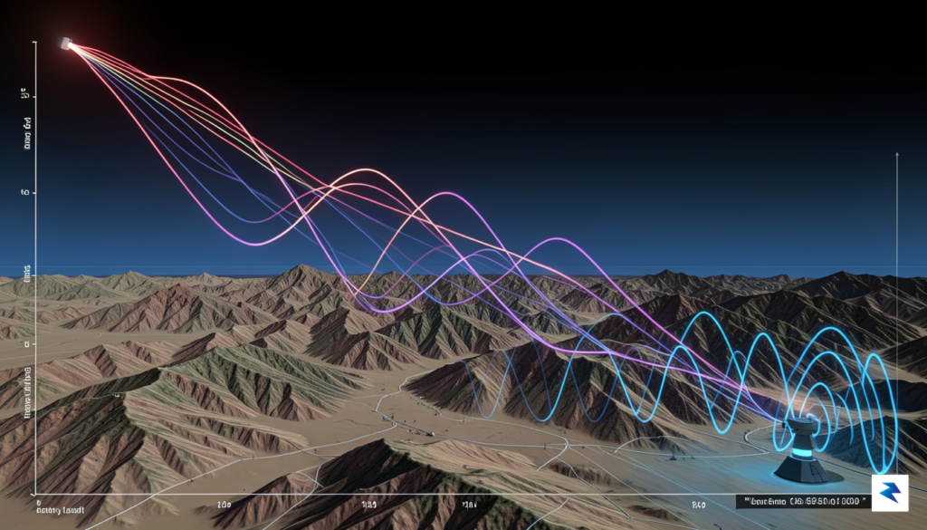
A cornerstone of this impending revolution is the proliferation of ‘SmallSat’ constellations. Unlike their larger, geostationary predecessors, these smaller, more agile satellites operate in low Earth orbit, often deployed in vast networks. This allows for near-constant observation of any given point on the globe, providing an almost live stream of critical areas post-disaster. Imagine an earthquake striking; within minutes, multiple SmallSats could be passing over the affected region, capturing high-resolution imagery and data, offering an unparalleled level of temporal detail that traditional, less frequent satellite passes simply cannot match. This persistent monitoring capability means emergency responders no longer have to wait hours or days for the next satellite pass, but can receive updated information almost continuously.
The sheer volume of data generated by these constellations, however, would be overwhelming without the parallel advancement of artificial intelligence and machine learning. These sophisticated algorithms are the unsung heroes, poised to drastically reduce the processing time of satellite and drone imagery from hours, or even days, to mere minutes. Machine learning models can be trained to instantly identify critical damage patterns, such as collapsed buildings, impassable roads, and ruptured infrastructure, extracting actionable intelligence from raw data at speeds impossible for human analysts. Furthermore, AI can compare pre-disaster imagery with post-disaster scans to automatically highlight areas of significant change, providing an immediate, objective damage assessment that guides rescue efforts and resource allocation with unprecedented precision.

Beyond technological prowess, the effectiveness of this future rapid-response ecosystem hinges critically on establishing robust global data-sharing agreements. Disasters transcend national borders, and a truly resilient response requires seamless international collaboration. These agreements would standardize data formats, ensure secure and immediate access to critical imagery and analyses across different agencies and nations, and overcome potential geopolitical hurdles that might otherwise delay vital information flow. Such frameworks would foster a truly interconnected global network where data from satellites owned by one nation could be instantly shared and processed by experts in another, creating a unified and highly efficient crisis response mechanism that prioritizes human safety above all else.
In essence, the convergence of ubiquitous SmallSat monitoring, intelligent machine learning analysis, and cooperative global data-sharing represents more than just an incremental improvement; it signifies a paradigm shift. This integrated approach promises to transform disaster response from a reactive, often chaotic scramble into a highly coordinated, data-driven operation, where information is power, delivered precisely when and where it’s needed most. The humanitarian impact of being able to assess damage, locate survivors, and guide aid efforts with such speed and accuracy is immeasurable, paving the way for a future where the destructive power of natural disasters is met with an equally powerful, technologically advanced human response.
You must be logged in to post a comment.